Maritime Analytics Platform (MAP)

Data-led analysis of current and future energy use across vessels, routes, and infrastructure.

Converting Clean Energy ambition into actionable, data-driven plans...

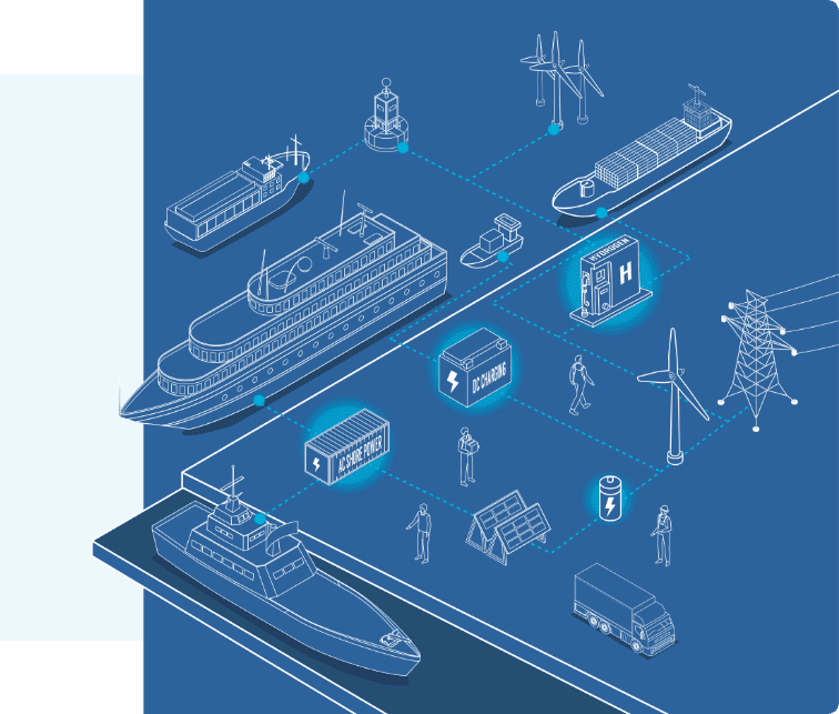
MAP is Marine Zero’s tailored consultancy service that provides a data-driven, real-world electrification roadmap for your vessel, fleet, or port. It breaks down the complexity of clean energy transition into four interlinked stages — delivering a technical, costed plan that supports investment, compliance, and long-term viability.

By providing accurate energy demand insights, MAP minimises grid connection requirements and associated costs. It also supports fuel and maintenance savings, unlocks flexible charging revenue opportunities, and strengthens eligibility for green transition funding.

MAP Marine Zero logo: blue 'MAP' letters with a green 'A', a vertical blue divider, and the word 'MARINE' in blue with a green 'zero' and a blue wave underline.
Isometric illustration of a maritime energy network: ships, a port, wind turbines, and connected charging blocks.

MAP delivers a complete electrification strategy – from vessel profiling to grid integration – ready for funding and delivery

1. Energy Assessment

Uses fused data – including AIS, engine logs, and onboard monitoring – to generate real-world operational profiles. Replaces assumptions with precision modelling, often reducing grid demand estimates and improving viability.

2. Vessel Feasibility

De-risks design and investment decisions. Confirms newbuild or retrofit suitability, preventing over- or under-specification. Ensures Class alignment and avoids costly rework.

3. Energy Supply Feasibility

Aligns vessel needs with onshore infrastructure. Accurately sizes grid demand, uncovers local supply potential, and supports flexible charging or vessel-to-grid (V2G) integration — accelerating planning approvals and cutting connection costs.

4. FEED Study (Front-End Engineering Design)

Fuses technical, commercial, and operational planning. Produces a fully costed, Class-aligned business case — ready for funding, stakeholder buy-in, or board approval.

De-risk & Optimise

Explore how MAP works for your assets and operations. Choose the customer type that best matches your needs.

Blue line drawing of a cargo ship with containers and a crane at a portdocked vessel in blue outline.
Ports & Harbours
Handshake over a signed contract document, symbolizing a business agreement.
Investors
Blue line drawing of a factory with two wind turbines in the background, symbolizing clean energy.
Manufacturers
Blue line illustration of a computer monitor, smartphone, gear, and wireless connectivity icons linked by circuits.
Technology Partners
Blue line drawing of a cargo ship with containers and a crane at a portdocked vessel in blue outline.
Ports & Harbours
Handshake over a signed contract document, symbolizing a business agreement.
Investors
Blue line drawing of a factory with two wind turbines in the background, symbolizing clean energy.
Manufacturers
Icon of a construction worker in a hard hat beside a gear symbol, standing at a podium-like base, representing engineering or safety.
Fleet Operators
Group of people with overlapping chat bubbles, representing team discussion and collaboration.
Public Sector
Blue line illustration of a computer monitor, smartphone, gear, and wireless connectivity icons linked by circuits.
Technology Partners

Your first step to electrification

MAP de-risks the early stages of your decarbonisation strategy by transforming operational data into clear, technical requirements. Whether you’re exploring the feasibility of a retrofit or investing in a zero emission vessel or fleet,   MAP is the essential first step in pre-design and cost modelling – providing a comprehensive technical foundation so that you can progress with confidence.

Our MAP platform is being continuously developed in parallel with new propulsion, storage, and charging or hydrogen technologies – making it a future-proof platform for clean maritime transition planning.

Aerial view of London with Tower Bridge over the Thames, modern skyscrapers to the right, boats on the river at dusk.